Contour Survey and Site Mapping Services by GPSCAD: Reliable Survey Solutions for Construction
Author : GPS CAD | Published On : 27 Oct 2026
Accurate land information is essential for successful construction, infrastructure development, and engineering projects. Understanding ground elevations, terrain variations, slopes, and existing site features helps professionals make better planning decisions. GPSCAD Survey Private Limited provides professional land surveying and digital mapping solutions to support developers, architects, civil engineers, contractors, and infrastructure consultants across India.
GPSCAD offers Contour Survey and Site Mapping Services to help clients understand site conditions and prepare reliable information for engineering design, grading, drainage planning, and construction. With modern surveying equipment and digital mapping technologies, the company supports projects requiring detailed and dependable land data.
What Is a Contour Survey?
A contour survey measures ground elevations and represents terrain variations through contour lines on a map. These lines connect points of equal elevation, allowing engineers to understand the shape and slope of the land.
Contour surveys are important for residential developments, commercial buildings, highways, industrial facilities, and large infrastructure projects. They help identify uneven terrain, evaluate drainage patterns, estimate earthwork requirements, and support effective site development.
GPSCAD uses suitable surveying methods to collect elevation data and prepare contour information according to project requirements.
Importance of Site Mapping
Site mapping provides a detailed picture of existing land conditions before development begins. Depending on the project scope, maps may include boundaries, ground levels, roads, structures, slopes, drainage features, and other physical elements.
Professional mapping helps engineers and architects plan building locations, coordinate infrastructure layouts, and identify potential site constraints. Accurate information at the planning stage can also reduce avoidable design changes and improve construction efficiency.
GPSCAD combines field measurements with digital processing to produce useful survey data for engineering and development applications.
Surveying Solutions Offered by GPSCAD
GPSCAD provides several surveying and mapping solutions to support different project requirements.
1. Topographical Survey: Captures ground levels, contours, roads, structures, and other natural or man-made features for planning and design.
2. DGPS Land Survey: Provides coordinate and geospatial data for land development, engineering projects, and infrastructure planning.
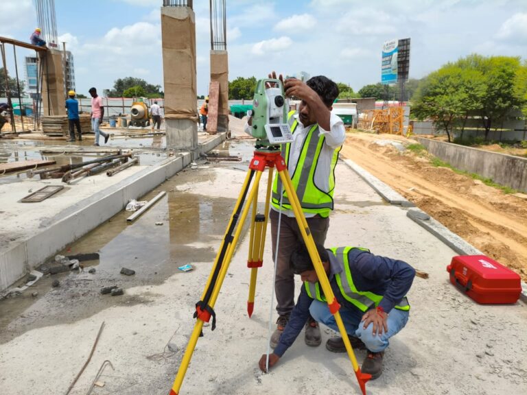
3. Total Station Survey: Measures angles, distances, coordinates, and site features for detailed mapping and construction positioning.
4. Drone Survey and Mapping: Uses aerial data collection to support large-area mapping, terrain analysis, and digital model preparation.
5. Construction Layout and Setting Out: Transfers design coordinates and dimensions onto the ground to guide construction activities.
6. AutoCAD and GIS Mapping: Converts survey measurements into digital drawings, maps, and spatial datasets for engineering and land management.
These services help clients select suitable surveying methods based on their site conditions, accuracy requirements, and project objectives.
Applications of Contour Survey and Site Mapping Services
Professional surveying supports a wide range of industries. In residential and commercial construction, elevation data helps engineers plan site grading and building placement. For highways and railway projects, topographical information supports route alignment, slope assessment, and drainage design.
Industrial parks and logistics facilities benefit from detailed site maps for infrastructure layouts and access planning. Renewable energy projects may require land assessment and terrain mapping before installation. Urban development projects can also use digital mapping to support infrastructure coordination and land management.
GPSCAD provides surveying solutions for infrastructure projects, industrial developments, transportation networks, and other construction applications across India.
Why Choose GPSCAD?
Choosing a reliable surveying partner is important for obtaining useful and consistent project data. GPSCAD highlights the following capabilities:
- Modern DGPS and Total Station equipment.
- Experienced survey engineers and GIS professionals.
- Digital mapping and CAD deliverables.
- Technical reports and project-specific survey solutions.
- Support for government, private, and infrastructure projects.
- Survey services across multiple locations in India.
Its surveying capabilities include DGPS, Static GPS, RTK, PPK, Auto Level, AutoCAD, GIS software, and Global Mapper. The appropriate instruments and methods depend on the project's technical requirements and site conditions.
By combining field surveying with digital processing, GPSCAD helps clients make informed decisions throughout planning, design, and construction.
Conclusion
Accurate surveying is the foundation of effective land development and infrastructure planning. Professional Contour Survey and Site Mapping Services help project teams understand terrain, plan drainage, evaluate elevation differences, and prepare detailed engineering designs.
GPSCAD Survey Private Limited provides surveying and mapping solutions designed to support construction, industrial, transportation, and infrastructure projects. Whether you need a contour map, topographical survey, DGPS measurements, or digital site mapping, GPSCAD can help you identify a suitable solution for your project.
Planning a construction or infrastructure project? Contact GPSCAD Survey Private Limited to discuss your surveying requirements and receive professional assistance.
Visit the official website: https://gpscad.com/survey-services/
Contact Details
- Registered Office: 261-A, Barra-6, Kanpur, U.P. – 208027
- Branch Office: SRS Tower, Faridabad, Haryana
- Phone: +91 8887868551, 7065151856, 8459437555
- Email: [email protected]
Choose GPSCAD for professional Contour Survey and Site Mapping Services and reliable land information to support your next development project.